Location Tracking for Photographers with GPS Logger and Trekarta
When it comes to Android apps for photographers, we are spoiled for choice. From depth-of-field and golden hour calculators to sun position and remote control apps – there are plenty of clever tools to choose from. But there is one particular app combination that can prove to be indispensable for any photographer on the move: a GPS logger and a GPX viewer. There are two main reasons for that.
Tracking your movements and saving them in the GPX format can come in handy for geotagging photos.
The ability to attach comments to the current location allows you to use the GPS logging app to note places you either photographed or you plan to photograph later. You can then use a GPX viewer app to see and manage bookmarked locations.
There are several apps that offer GPS logging and viewing, but you can’t go wrong with GPS Logger for Android and Trekarta. Both apps are released under an open source license, and they are available free of charge on Google Play and F-Droid.

How you set up GPS Logger for Android is a matter of personal preference. One way to go is to configure the app to automatically start tracking on boot and upload tracks to the desired destination (e.g., a NAS or a file sharing service).
Once GPS Logger for Android is running, adding a comment to the current location is as easy as pulling down the notification drawer and tapping Comment. The app saves the tracks as GPX files in the Android/data/com.mendhak.gpslogger/files directory on your Android device. To view a GPX file in Trekarta, use a file manager to navigate to the directory, and use Android’s sharing functionality to send the desired GPX file to Trekarta.
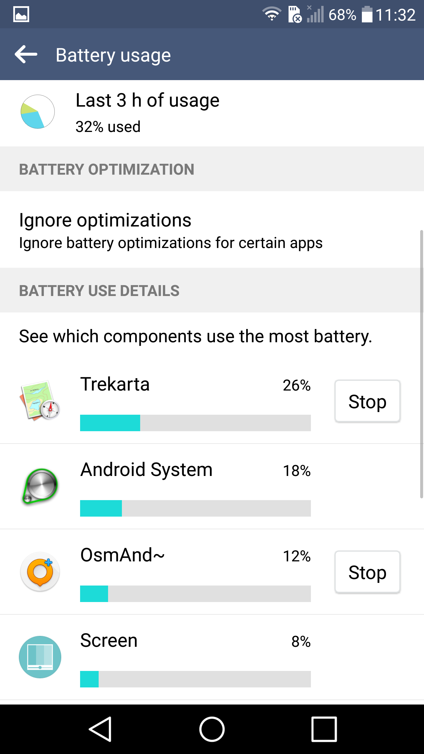
In the above screenshot, you see the battery stats from the Android battery settings dialog, which clearly show how Trekarta uses much more battery than OsmAnd. Now it’s possible that OsmAnd is delegating that to “Android system” in which case it would use slightly more battery (4%) but I think it would be unfair to assume all of that battery usage goes to OsmAnd.
OsmAnd also supports taking pictures straight from the app which, naturally, adds the necessary GPS data… I rarely tag my pictures with location metadata, mostly for privacy reasons, but I sometimes use that feature to do edits to OpenStreetMap…
I use OsmAnd (actually its paid version, OsmAnd+) and find it awesome too, but I think it’s not open source.
I’ve tried loading a test gpx track in Trekarta but from my phone I couldn’t find a way to share the gpx file to Trekarta. It simply doesn’t show up in the app list.
On the other hand, OsmAnd offers the possibility to record gpx tracks and display them, all in the same app.
I’ve used OsmAnd extensively too, either as a driving GPS guide in my area, or as an offline map when I visited some places (Paris, New York, Venice…) on which I had put my own points of interest.
Once you got your GPX files I find ExifTool (of course FLOSS) to do the best job of adding GPS data to files. Geotagging with ExifTool - info. In short it’s as easy as exiftool -geotag data*.gpx -ext CR2 -R . (for recursive tagging .cr2 from all GPX data source files that fits mask data.gpx. As with every file manipulation, it’s good to have backup, but Exiftool is known for its solid work of not destroying files. With a bit meddling you can even get place name (city, district) to XMP/IPTC metadata.
I’d heavily recommend not changing the artifacts produced by your camera , eg. Cr2 net orf or what have you. Instead you can write the location coordinates to a sidecar file such as xmp or pp3. Exiftool supports writing to xmp files.
OrganicMaps is also a decent open source map which uses OSM data, I find it really reliable and lightweight. Plus it also works in offline mode with only GPS
Its an artifact from your photo session and is unique. You likely can’t replace it. Unless you’re willing to check every file after you modify it, how will you know if a file has become damaged?
The workflow and sidecar files allow for association and adding of metadata, so I use that.
After tagging about 100k raw files from a few cameras (MRW, NEF, different CR2) I never had any problem, so I’m not checking anymore. I don’t like sidecar files, but as I said - it’s up to user.
OrganicMaps is also a decent open source map which uses OSM data
Yeah, one of the best maps available now IMO. I think it wasn’t available when this article was written.
I have OsmAnd (following recommendations found here) and it doesn’t work that well. It seems to stop recording by itself (or is killed by the OS). It is possible that this is the Xiaomi version of Android that does this… because another “always on” app(*) has a strange behavior at times.
(*) KDE connect. If you use Linux with KDE on your PC, it’s a very cool thing.
I am running lineage OS with OSMand from fdroid and I don’t have this problem. Some manufacturers bake in “power saving” stuff, so you should checkthe allow list for things of that nature. No idea what that’d be on xiami.
I had the same issue with my Note4X, and I found a setting to prevent the OS from killing OSMand. Unfortunately I don’t have that anymore and I don’t remember which setting I modified.