I loved the smaller islands of the Cyclades, especially Sifnos, Serifos. In the Dodecanese, I loved the colorful town in Simi, the stunning volcano on Nisiros, and of course the old town of Rhodos. What a beautiful place (and amazing food, too).
2 Likes
A non-photographer friend went to Torres del Paine (in a campervan…) and even her phone pics looked incredible
2 Likes
Isn’t that like the Dolomites?
I don’t know if you’d consider traveling to South America, but the Lençóis Maranheses, in Brazil, are simply stunning: Parque Nacional dos Lençóis Maranhenses – Wikipédia, a enciclopédia livre
1 Like
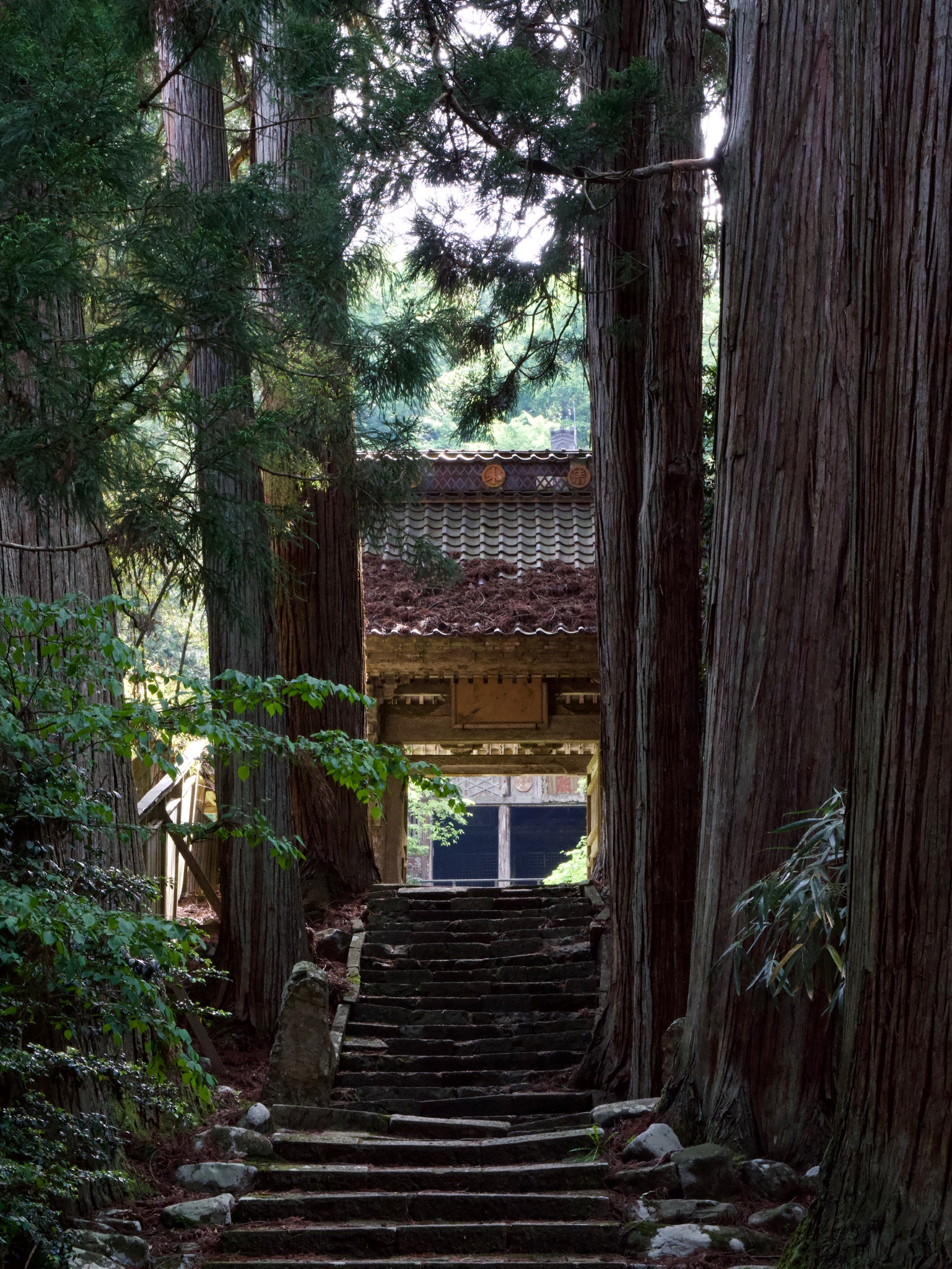
I never made it to Shiretoko peninsula in Hokkaido when I lived in Tokyo but plan to one day. There are lots of places for fall leaves in Hokkaido, apparently, though also a ton of domestic photographers shooting them. I loved the ancient cedar forests and mossy forest floor of Yakushima (inspiration for Studio Ghibli anime like Spirited Away), though they’re quite dense for photography, I guess. I was only taking photos with my phone at the time.
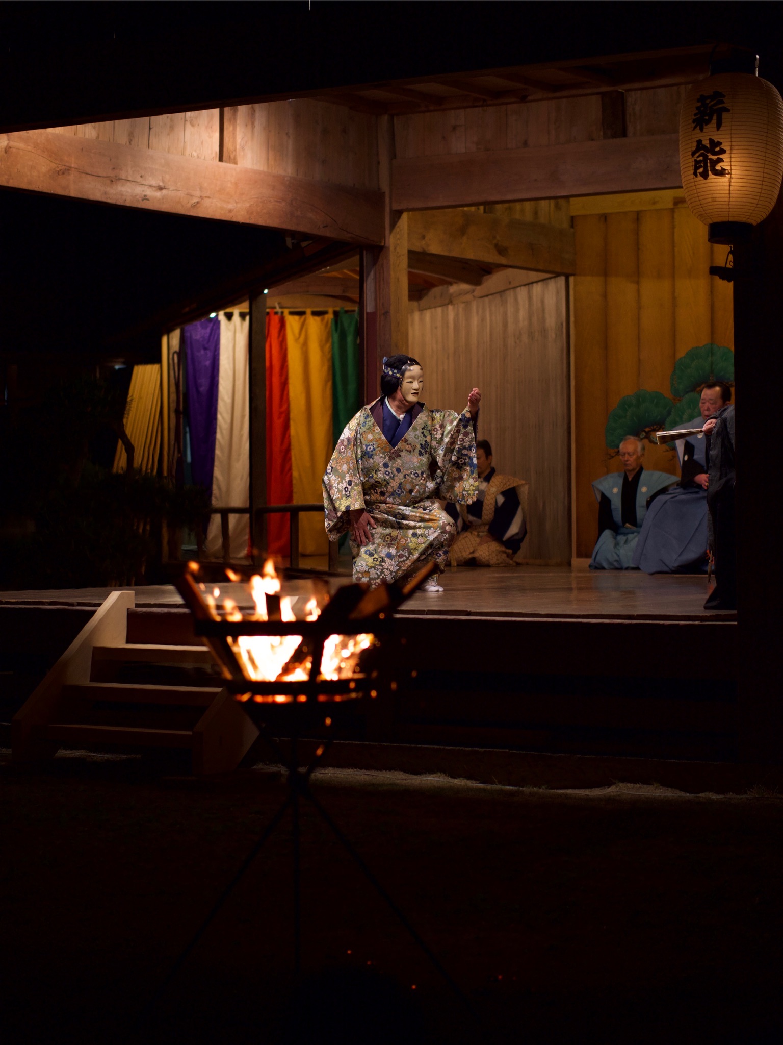
Sado island close to Niigata has outdoor noh plays (many local photographers when I attended) and abandoned teak villages and temples, though they’ve dumped so many tetrapods along the coast.
3 Likes
I’ve not been to either…
1 Like
British Columbia = semi-arid desert, temperate rainforest, boreal forest and alpine tundra biomes all with int 2-3 hours drive of each other on top of Greater Vancouver urban stuff and Vancouver Island.
I’m slow to update my website for now but here’s just two parts on BC, coastal and interior Arek Halusko | Flickr
If you hit the foresty roads you get even more variety
2 Likes
I’m thinking you would find some amazing shots here…
My wife is doing a 160 mile canoe trip this summer… I’m hoping she takes a few pics along the way ![]()
2 Likes
Take the night train from Vienna to La Spezia and then visit the cinque terre. A climate-friendly and relaxed trip to a great place:
https://www.google.com/search?q=cinque+terre&client=firefox-b-d&sxsrf=APwXEdfcyvHOy-9HOPqnamQZUNyHx_ZXrQ:1683104020525&source=lnms&tbm=isch&sa=X&ved=2ahUKEwi2po2K49j-AhUx_rsIHd-jCzcQ_AUoAXoECAIQAw&biw=1920&bih=919&dpr=1
2 Likes
Totally bookmarked this post with all these great ideas… Planning trip to Sao Paolo, Brazil, to use up covid-era flight credit. Any suggestions in that region are welcome!
I do have the plan to visit my cousin in the u.s. eventually and I also want to see the pacific but at the moment I have a tendency towards destinations in Europe.
1 Like
![]()
![]()
There actually is a direct night train from Vienna to La Spezia!
Come and see the nothingness that is the deep south “landscape”. It’ll renew your appreciation for ANY landscape elsewhere. LOL ![]()
1 Like
For us foreigners: What specific part of the US do you designate by “deep south” or “nothingness”?
(It was a tremendous experience the first time I, in my youth, traveled for hours on within a totally flat scenery in the inner part of Yugoslavia … so different from home. ![]() )
)
2 Likes
It is a region of the United States. As a “Deep Southerner” myself, I consider it to be comprised of Louisiana, Mississippi, Tennessee, Alabama, Florida, Georgia, South Carolina, and North Carolina. Some would also include Arkansas, Kentucky, and Virginia, and maybe even Texas.
1 Like
The deep south are those states immediately adjacent to the Gulf of Mexico, plus (in some contexts) those adjoining them. A gross generalization would be a swath extending from southeast Texas, across Louisiana, Mississippi, Alabama and Florida. However, culturally Arkansas, Georgia, South Carolina, etc., might be included in the term and possibly even others such as Oklahoma, Tennessee and North Carolina.
Weather and climate wise, we’re dominated by the Gulf of Mexico and interactions with cooler / dryer air coming in from the north / western US. We generally get plenty of rain (often 60 inches / 150cm or more annually), it’s often overcast and almost always humid (Koppen “humid subtropical” climate). Tropical weather such as hurricanes are not at all uncommon.
I’m in central Louisiana and that’s my (somewhat tongue-in-cheek) reference to “nothingness”.
We have at most just a few slight rolling undulations in our topography. With 100 foot tall pine trees commonplace, the elevation change is almost never more than the height of the trees so you can’t see above / beyond anything. Mississippi and Alabama have in places slightly more hilly terrain. Arkansas and Georgia have what might be termed “smaller” (i.e., sub-Appalachian sized) mountains. For example, 1,500 foot elevation change can be found in Arkansas. However, the highest point in Louisiana is the somewhat comically-named Driskill Mountain. At 535 feet, from what I’ve seen of photos it requires a sign in the middle of an apparently flat pine forest to indicate you’ve reached the “summit”. LOL
In Louisiana, there are a handful of distinct landscapes:
-
Populated areas (towns)
-
Wide open flat commercial farm land typically measured in thousands (if not tens of thousands) of contiguous acres
-
Seasonally or perpetually flooded cypress swamps
-
Dense, mostly pine, forest. It’s also typical to be heavily undergrown with dense vegetation, vines, etc., to the point where periodic prescribed burns are necessary to keep things in check.
-
Coastal delta / marsh
-
New Orleans
That last bullet point isn’t a joke. New Orleans is in Louisiana but in many respects is unlike anywhere else in the state. Yes, it’s flat and low (below sea level) but the city itself is actually more reminiscent in some regards of New York than Louisiana. For example, one of the common language accents in New Orleans pronounces the city as “nuh-WAH-luns”, much like a more northeast US accent might. I seem to recall reading somewhere that New York and some of New Orleans have some ancestral overlap, which might explain it.
So, to get back to your question at long last… ![]()
Basically take any landscape and remove all effects of elevation change, then you can imagine most of Louisiana. No (real) hills, no valleys, no cliffs, no waterfalls, no vistas, no sea stacks and a coast line where elevation change is measured in inches per mile (almost).
Way, way, way TMI, I know… ![]()
5 Likes
You wrote your much more concise reply while I was typing… Maybe I should’ve just read yours first! ![]()
1 Like
São Paulo itself is great for street photography and urban landscapes, if you like that type of photography. If you plan to go from São Paulo to a beach, I’d recommend the ones at the north of the São Paulo state - a bit farther from São Paulo city, but much more interesting than the nearest ones. Ubatuba is a great beach destination, a bit over 3 hours from SP by car.
1 Like
Thank for this extensive lowdown on the geography of Lowisiana and its towering surroundings.
Interesting for us geografreaks. Was not aware it is that flat.
Learned something today, too. ![]()
2 Likes