Hi,
I took a lot of photos and forgot to geotag them before importing to Darktable. Since I have so many files (~1800 photos), and I took them all in the same place (thank goodness), I decided to use exiftool to tag all of the RAW files. Unfortunately, even though I tagged the file, the latitude and longitude aren’t showing up in the Darktable UI, and exporting the processed RAW file as a jpg doesn’t include the coordinates.
I’m not sure what I’m doing wrong, and I would appreciate some help.
Just to try to reduce the problem, I tried tagging one file like this:
> exiftool -GPSStatus='Measurement Active' -GPSLatitude="35 deg 27' 25.1208\" N", -GPSLongitude="139 deg 38' 7.4364\" E" -GPSLatitudeRef=North -GPSLongitudeRef=East /Users/aaron/Pictures/Darktable/20250915_japan-wedding/20250915_0221.ORF
    1 image files updated
I verified that the RAW file was updated:
> exiftool /Users/aaron/Pictures/Darktable/20250915_japan-wedding/20250915_0221.ORF | grep GPS
GPS Version ID                  : 2.3.0.0
GPS Latitude Ref                : North
GPS Longitude Ref               : East
GPS Status                      : Measurement Active
GPS Latitude                    : 35 deg 27' 25.12" N
GPS Longitude                   : 139 deg 38' 7.44" E
GPS Position                    : 35 deg 27' 25.12" N, 139 deg 38' 7.44" E
If I check the file info in the macOS finder, I can see macOS understands it has a lat / long:
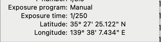
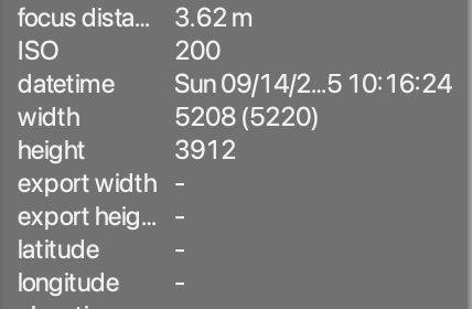
But Darktable doesn’t seem to update:
I noticed that correctly geotagged photos will have GPS entries in the XMP sidecar, so I tried using exiftool to update the sidecar:
> exiftool -GPSStatus='Measurement Active' -GPSLatitude="35 deg 27' 25.1208\" N", -GPSLongitude="139 deg 38' 7.4364\" E" -GPSLatitudeRef=North -GPSLongitudeRef=East /Users/aaron/Pictures/Darktable/20250915_japan-wedding/20250915_0221.ORF.xmp
Warning: [minor] Ignored empty rdf:Seq list for darktable:masks_history - /Users/aaron/Pictures/Darktable/20250915_japan-wedding/20250915_0221.ORF.xmp
    1 image files updated
I can see exiftool does indeed update the XML file, but the output XML isn’t the same as what Darktable uses. For example, this XML came from a properly tagged photo that was imported to Darktable:
  <rdf:Description rdf:about=""
    xmlns:exif="http://ns.adobe.com/exif/1.0/"
    xmlns:xmpMM="http://ns.adobe.com/xap/1.0/mm/"
    xmlns:xmp="http://ns.adobe.com/xap/1.0/"
    xmlns:darktable="http://darktable.sf.net/"
    xmlns:dc="http://purl.org/dc/elements/1.1/"
    xmlns:lr="http://ns.adobe.com/lightroom/1.0/"
   exif:DateTimeOriginal="2025:09:13 12:49:19.000"
   exif:GPSVersionID="2.2.0.0"
   exif:GPSLongitude="139,37.956600E"
   exif:GPSLatitude="35,27.281500N"
   exif:GPSAltitudeRef="0"
   exif:GPSAltitude="0/10"

...
And this is what exiftool did when I asked it to update an XMP file:
 <rdf:Description rdf:about=''
  xmlns:exif='http://ns.adobe.com/exif/1.0/'>
  <exif:DateTimeOriginal>2025:09:14 10:16:24.000</exif:DateTimeOriginal>
  <exif:GPSLatitude>35,27.41868N</exif:GPSLatitude>
  <exif:GPSLongitude>139,38.12394E</exif:GPSLongitude>
  <exif:GPSStatus>A</exif:GPSStatus>
 </rdf:Description>
I’m unsure how to properly tag these files, and I have so many I really don’t want to do it via the UI. Anyway, I’d really appreciate help!
Thanks